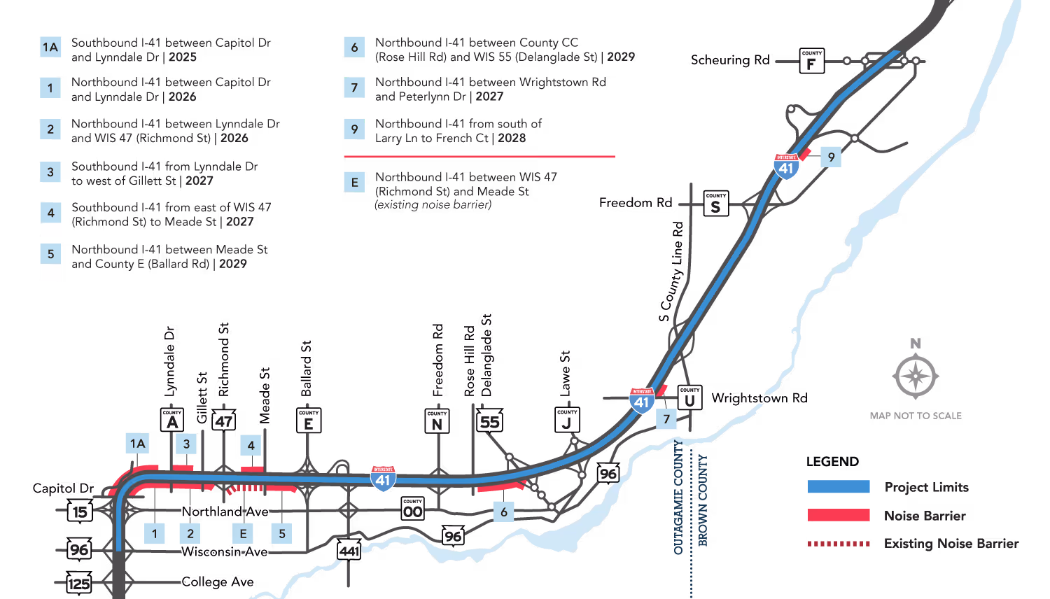
WisDOT completed a full noise analysis during the preliminary design and the environmental documentation phase of the I-41 Project.
The results, along with proposed barrier locations, were published in the I-41 Project Environmental Assessment and at the public hearing in 2021.
Six new noise barriers and one existing noise barrier (between WIS 47 and Meade Street) were determined to be reasonable and feasible (see map below).
As the project heads into final design, WisDOT will confirm the noise analysis findings using the final designs of the highway, including any updates to the alignment, height of the road and drainage features.
Confirmation of the noise analysis is a key step, as it optimizes the details of the proposed barriers, enables minor adjustments to accommodate site conditions, and evaluates options for potential cost savings.
After the noise analysis is confirmed and the final barrier layouts for each barrier are complete, WisDOT will mail voting materials – noise barrier meeting invitation, location map, and a ballot – to benefited property owners and tenants located in the immediate vicinity of each proposed barrier.
Benefited receptors will be asked to vote to confirm whether the barrier should be constructed as part of the I-41 Project.
A simple majority of votes will determine whether WisDOT constructs the barrier.
The 23-mile I-41 Project segment has four travel lanes – two lanes in each direction. The segment is congested and has a higher rate of crashes than similarly configured freeways in Wisconsin. By federal standards, the project area has multiple roadway design deficiencies, and much of its pavement and several bridges are nearing the end of their useful lives and must be replaced.
The National Environmental Policy Act requires an environmental assessment to document study data that determines whether a federal action such as a transportation project could cause significant environmental effects. The assessment typically includes a discussion of the purpose and need for a proposed action; alternatives and the potential environmental impacts of the proposed action and alternatives; and an accounting of the agencies and stakeholders (including affected members of the public) an agency consults about the proposed project and alternatives.
A Finding of No Significant Impact is a federally approved document that presents the reasons why an agency such as WisDOT has concluded that an action such as a transportation project will not produce significant environmental impacts.
System interchange is used to identify interchanges that connect two or more freeways. System interchange connections should be high speed and free flowing to provide all directional movements.
Service interchange applies to interchanges that connect a freeway with local surface streets or arterials. Service interchange ramps may be a low-speed, free-flowing, or may require a stop at the connection to the local or arterial street.
An auxiliary lane is an extra lane added between interchange on and off ramps. It is used for speed changes and the maneuvering of entering and exiting traffic. The lanes are an efficient way to weave into and out of traffic while lessening congestion in the through lanes. Auxiliary lanes balance the traffic load and maintain a more uniform level of service on the highway.
A collector-distributor road, or C-D road, is a limited-access road that carries traffic from local roads and arterial roads to freeways or highways. The purpose of a C-D road is to eliminate weaving and reduce the number of exit and entrance points on the freeway.
Based on study data, the current 70-mph speed limit is appropriate for I-41.
Studies show that highways operate the most safely when most vehicles are moving at roughly the same speed. Lowering I-41’s speed limit to 55 mph would increase variations among vehicle speeds and the actions that cause safety issues such as changing lanes to avoid slower vehicles and dangerous merging. State and national safety studies found that wide gaps among vehicle speeds are very likely to decrease the overall safety of the roadway.
A speed study completed for I-41 found the prevailing speed (85th percentile) ranged from 76.1 to 77.8 mph and the average speed ranged from 69.1 to 71.4 mph. I-41 is an Interstate designed for a 70 mph speed limit, and most motorists drive at speeds consistent with a roadway’s geometrics and environment.
Brown and Outagamie counties’ Highway Traffic Safety committee, which include representatives with the Wisconsin State Patrol, local law enforcement, local and county officials, health departments, and safety and driver education groups, meet on a quarterly basis with WisDOT to review all severe and fatal crashes and evaluate best practices for crash mitigation and incident response.
WisDOT also works with emergency responders to develop coordinated protocols and preplanned emergency alternate routes to maximize response efficiencies during incidents.
The WisDOT Safety Patrol sponsored by Geico is also active between WIS 96 and County F (Scheuring Road) to help drivers in the event of a breakdown or minor crash. The safety patrol offers free, limited roadside assistance to drivers in need.
The transportation improvement process from inception of environmental study to breaking ground for a construction project of this size and scope is likely to track quite similarly with other projects of its size/scale. WisDOT continuously pursues efficiencies and best practices. The public may find this process to construction faster than other typical projects of its size and scope because of the unique way that it was legislatively approved and has study and construction funded from the start.
Like the large-scale improvement projects in Winnebago and Brown counties, traffic staging plans will be developed and refined throughout the preliminary and final design of project sections. The department will follow industry accepted standards and guidelines to implement the most effective traffic management strategy.
The Brown County reconstruction had distinct project limits evaluated for addressing that project’s purpose and need. Transportation Project Commission authorization/enumeration by way of funding of that construction work was predicated on the environmental study they authorized/enumerated.
Yes. The selected alternative includes expanding the four-lane highway to six lanes. The additional lane will be construction in the existing median; however, interchange reconstruction or the construction of new noise barriers will require real estate. The project’s Finding of No Significant Impact describes the potential impacts the project may produce. WisDOT will determine the exact location and amount of real estate required as the design progresses.
Yes, as part of the environmental study, WisDOT conducted a noise analysis. Six new noise barriers and the existing noise wall in the project area were determined to be feasible and reasonable.
The final location of noise walls will not be decided until later in the project design process. There is an interactive process with which we will work with affected owners, tenants and local entities on any necessary noise infrastructure in terms of determinations, consensus/voting, aesthetics, and maintenance. Areas with existing noise walls will have impacts of the reconstruction project evaluated as well.
WisDOT will engage and collaborate with municipal and county representatives so that facilities designed and constructed as part of the I-41 Project – such as lane configurations and pedestrian and bicycle accommodations – complement local and regional transportation planning efforts.
For additional information on Brown County's South Bridge Project, please visit:
https://www.browncountywi.gov/departments/highway/general-information/south-bridge-connector/
Project contact:
Cole Runge
Brown County Planning Director/MPO Director
PO Box 23600
Green Bay, WI 54305-3600
(920) 448-6480
South.bridge.connector@browncountywi.gov
WisDOT is replacing the Wrightstown Safety and Weight Enforcement Facility (SWEF), which is about ¾ miles south of County U in Outagamie County, to protect the reconstructed I-41 from overweight vehicle use that could damage the project’s new structures and pavement. The existing facility also requires updated technology and equipment to weigh and inspect commercial truck traffic.
Project construction will impact access to and operations at the current Wrightstown SWEF.
The Wisconsin State Patrol, whose current headquarters in Fond du Lac requires significant upgrades, will move its Northeast Region Headquarters to the new Wrightstown SWEF, which is located more centrally to the region. Co-locating in the new facility will cost less than upgrading the current patrol headquarters.
WisDOT will replace the following six of the eight local and county road overpasses over I-41:
The existing overpass bridges at Lynndale Drive (County A) and Meade Street will remain in place.
The reconstructed overpasses will have the same number of lanes but be wider than the existing ones to accommodate bicyclists and pedestrians and meet minimum design standards.
The project will reconstruct the following three interchanges with I-41 as diverging diamond interchanges (DDIs):
The innovative DDI configuration, sometimes called a “double crossover diamond,” accommodates more traffic than conventional interchange designs and allows drivers to make free-flow right and left turns onto freeway ramps.
Given the large volume of traffic making left turns to access I-41 from the three locations listed above, the DDI alternative best addresses safety concerns and traffic operations.
DDIs are comparable in cost to other diamond interchange alternatives and reduce the number of ways vehicles can collide by almost half (14%) compared with conventional diamond interchanges (26%).
DDIs help drivers easily navigate the interchange with overhead signs, pavement marking and traffic signals, and the design accommodates all road users: large trucks, pedestrians and bicyclists.
The DDI alternative also provides additional safety benefits for pedestrians including signal protection at almost all crossing points in the interchange.